
Page introduction
The Punakha Winter Trek follows an old walking route from the Thimphu side towards the warmer Punakha Valley. From Dechencholing and Chamina, the trail climbs towards Sinchula, then descends through forest, villages and cultivated countryside to Chorten Ningpo and Zomlingthang. The contrast between upland forest and subtropical valley scenery makes this a rewarding short trek.
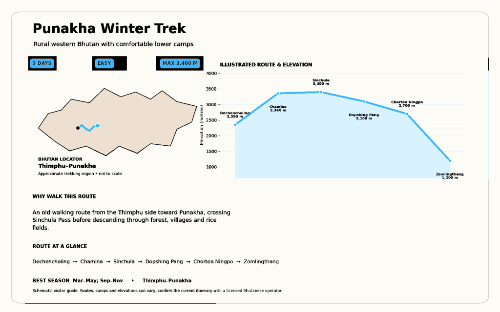
Quick facts
| Detail | Information |
|---|---|
| Duration | 3 days |
| Difficulty | Easy |
| Maximum elevation | 3,400 m |
| Best season | March–May; September–November |
| Route | Dechencholing → Chamina → Sinchula → Dopshing Pang → Chorten Ningpo → Zomlingthang |
| Best suited to | Beginners, mixed-interest groups and travellers combining Thimphu with Punakha |
Highlights
- Walk from the Thimphu region towards Punakha rather than driving the entire way.
- Cross Sinchula and descend through several vegetation zones.
- Pass villages, farms, temples and terraced fields.
- Finish within easy reach of Punakha’s cultural attractions.
Indicative itinerary
- Dechencholing/Chamina towards Sinchula: Start north of Thimphu and climb through forest to the first camp area.
- Cross Sinchula to Dopshing Pang: Complete the high point, then begin the descent towards warmer valleys.
- Dopshing Pang via Chorten Ningpo to Zomlingthang: Walk through settled countryside to the Punakha-side roadhead.
What to expect
The route is short and non-technical, but the climb to 3,400 metres can feel strenuous. Pack layers for a cold upland camp and lighter clothing for Punakha. The name “winter trek” describes its comparatively low and accessible character; this supplied season list focuses on spring and autumn.
Frequently asked questions
Does the trek visit Punakha Dzong? The trail itself ends near Zomlingthang. A visit to Punakha Dzong can be added before or after the trek by road.
Is camping required? Standard itineraries use supported camping on the route, though exact arrangements should be confirmed with the operator.